
Dormagen

Kopfstein-Pflasterung und eine kleine Aufmauerung vor dem Alten Rathaus im Herzen der  Dormagener Innenstadt. Die Steine liegen im Verlauf der römischen Lagermauer.
Image:

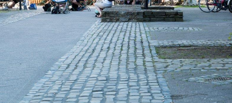
You can still see the line of the camp’s ramparts in the cobblestones in front of Dormagen’s old town hall (Altes Rathaus).

Auxiliary camp at Durnomagus, Burgus

A Roman cavalry camp occupied the site of present-day Dormagen from around 80 AD until approx. 161 AD. This is the first time that excavations along the Lower Germanic Limes have revealed traces of the pits that collected horse urine, confirming the existence of stables. After the original fort was destroyed in a fire, it was replaced by a smaller fortress. It was built in a corner of the old fort with the help of the existing ramparts and remained in use until around 430 AD. Traces of the structure of the ancient cavalry fort are still visible in the city today.

Access: public and private

Note:
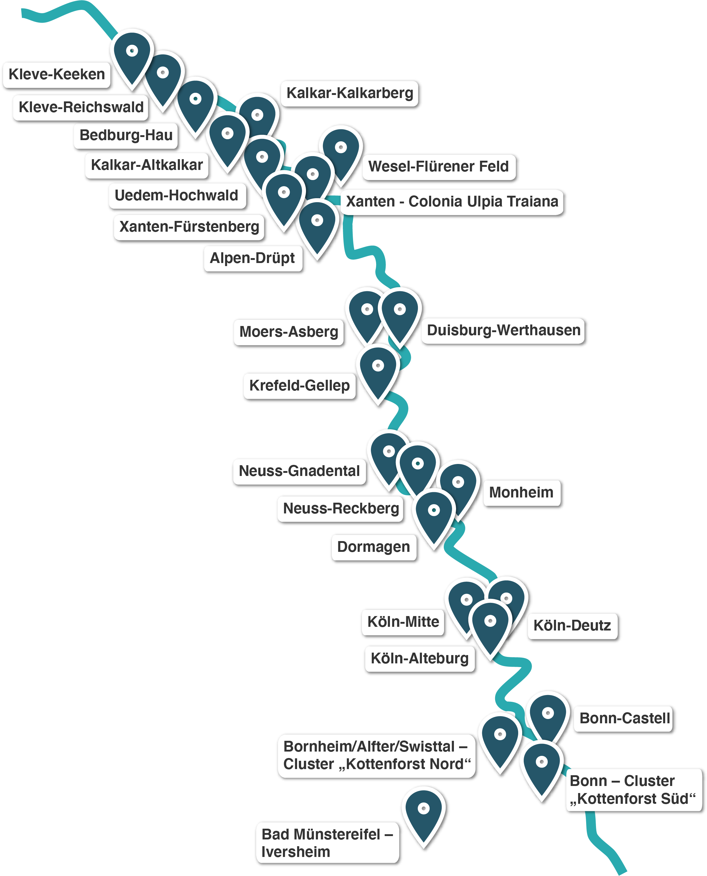
The archaeological remains that make up the Lower Germanic Limes (NGL) UNESCO World Heritage Site are all very well preserved. Most of these structures are buried underground and well protected. Some are visible above ground. So far, there is very little on-site information explaining the history and significance of these finds. We are currently working on a comprehensive package of information and presentation resources to promote public understanding of these sites.

The best Roman sites near you
The best Roman sites in North Rhine-Westphalia

Abschnitt Via Belgica, römische vici, Straßenstation

L 136
52457 Aldenhoven
Deutschland

Vier Kilometer langer Abschnitt der römischen Via Belgica durch das heutige Aldenhoven, der exakt dem antiken Straßenverlauf entspricht.

N 50°52'43" E 6°14'6"
> Learn more

Reste Kastell Divitia

Urbanstraße 1
50679 Köln
Deutschland

Reste des Osttores und Teile der Außenmauern des spätantiken Brückenkopfkastells sind erhalten.

N 50°56'18" E 6°58'11"
> Learn more

Wachtturm (Rekonstruktion)

Am Reckberg, Grimlinghausen
41468 Neuss
Deutschland

Ende des 19. Jahrhunderts legte der Neusser Archäologe Constantin Koenen auf dem Reckberg die Fundamente eines Wachturms frei, der den Römern wohl auch zur Übermittlung von Signalen gedient hatte. 1991 errichtete man unweit dieser Fundstelle eine Rekonstruktion des Bauwerks.

N 51°10'13" E 6°46'40"
> Learn more

Vicus Iuliacum / Abschnitt Via Belgica

Bühne, Kirmesbrücke
52428 Jülich
Deutschland

13 ha umfassende römische Zivilsiedlung an der Via Belgica mit Bestattungen.

N 50°55'43" E 6°21'37"
> Learn more

Sarkophage (nicht zugänglich)

Giesdorfer Allee 100
50997 Köln
Deutschland

Die zu einem Gutshof in Godorf, Godorfer Hauptstr. 171, zugehörigen Sarkophage sind im 400 m entfernten Garten aufgestellt.

N 50°51'50" E 6°57'54"
> Learn more

Spätrömischer Burgus "Villenhaus"

Brühl
50321 Hürth
Deutschland

Römischer Straßenposten aus dem 3. Jh. am höchsten Punkt der Ville.

N 50°49'6" E 6°53'22"
> Learn more

Vicus Thorr/Tiberiacum

Römerstraße 47
50127 Bergheim
Deutschland

Römische Straßen-Siedlung des 1./2. Jahrhunderts mit Abfallgruben, Brunnen und einem Grabbezirk. Außerdem lag wohl ein Heiligtum in der Nähe.

N 50°56'16" E 6°38'1"
> Learn more

Grabkammer

Äußerer Grüngürtel, südl. Kalscheurer Weiher
50997 Köln-Zollstock
Deutschland

einfache, rechteckige Grabkammer aus Tuffsteinen

N 50°53'29" E 6°56'5"
> Learn more

Abschnitt Via Belgica, villa Rustica

In der Widdau, Dechant-Hansen-Allee
50226 Frechen
Deutschland

Die Via Belgica war die römische Fernstraße von Köln nach Boulogne-sur-Mer. Etwa 60 Kilometer der Straße liegen im heutigen Rheinland. Sie verläuft von dort durch die niederländische Provinz Zuid Limburg über die Wallonie in Belgien bis zur Küste an den Ärmelkanal.

N 50°56'23" E 6°45'31"
> Learn more

Abschnitt Via Belgica, Vicus mit Gallo-römischem Umgangstempel

Gladbacher Straße 58
50189 Elsdorf
Deutschland

Vom 1. bis ins 4. Jahrhundert bewohnte römische Siedlung an der Via Belgica mit gallorömischem Umgangstempel, Bestattungen, einer Straßenstation und Gutshöfen.

N 50°56'11" E 6°34'1"
> Learn more
The towns and cities along the Limes in North Rhine-Westphalia
Kleve-Keeken Kleve-Reichswald Bedburg-Hau Kalkar-Kalkarberg Kalkar-Altkalkar Uedem-Hochwald Wesel-Flürener Feld Xanten - Colonia Ulpia Traiana Xanten-Fürstenberg Alpen-Drüpt Moers-Asberg Duisburg-Werthausen Krefeld-Gellep Neuss-Gnadental Monheim Neuss-Reckberg Dormagen Köln-Mitte Köln-Deutz Köln-Alteburg Bonn-Castell Bornheim/Alfter/Swisttal/ Cluster Bonn - Cluster Bad Münstereifel - Iversheim