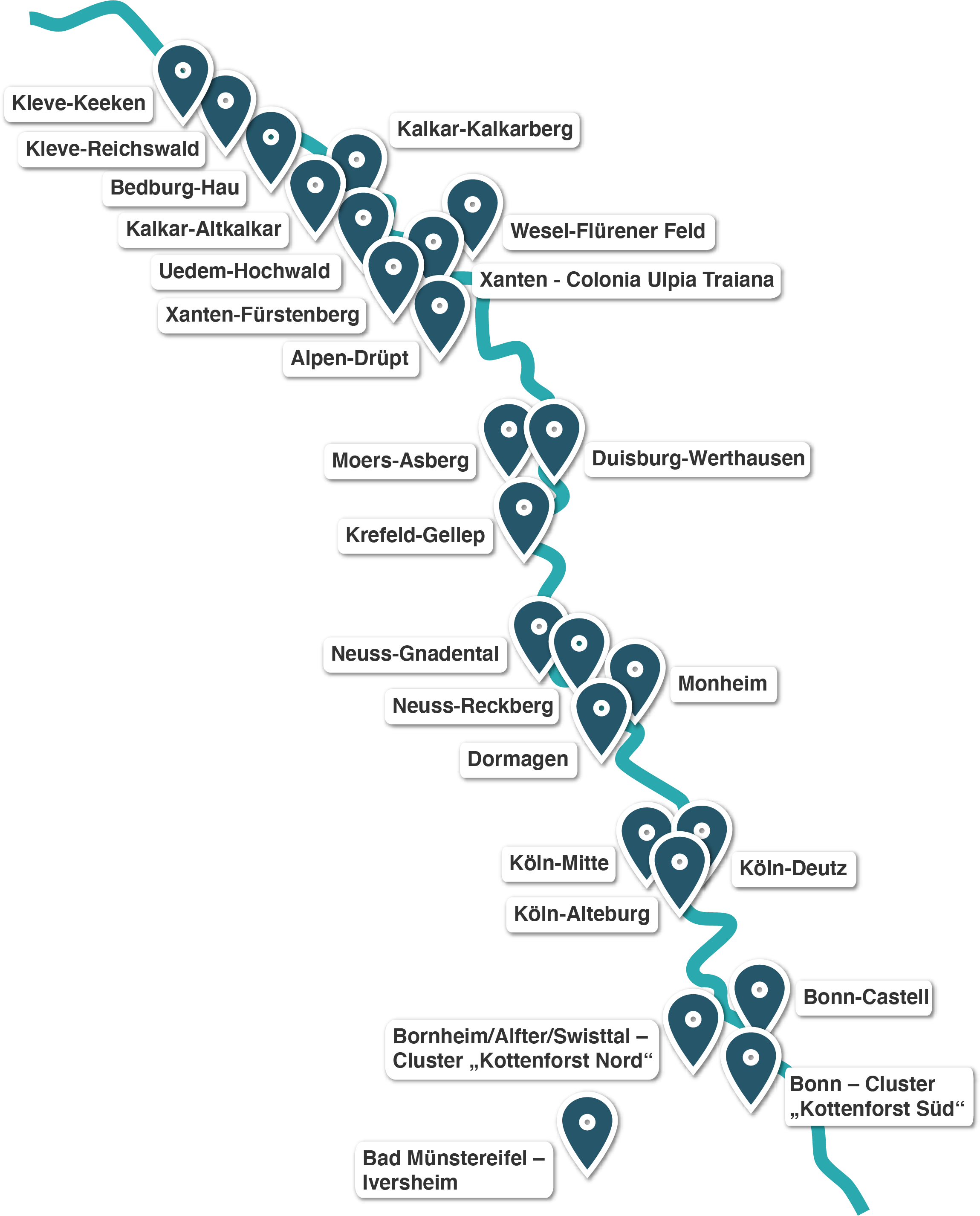
Moers-Asberg

Eine Informationstafel in Moers-Asberg als Hinweis auf den ehemaligen Lagerbereich.
Image:

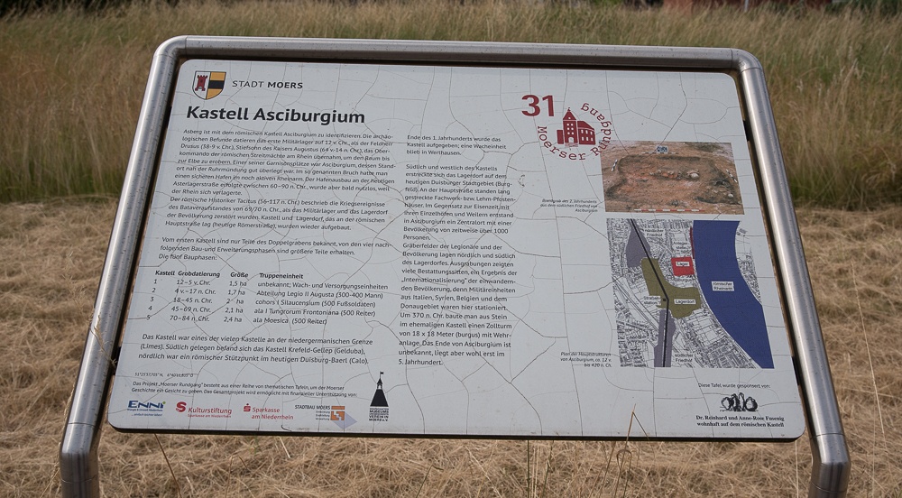
Information boards draw attention to the existence of an auxiliary camp in Moers-Asberg.

Auxiliary camp at Asciburgium

The Asciburgium auxiliary camp that was excavated in present-day Moers-Asberg provides evidence of how auxiliary soldiers were housed along the Lower Germanic Limes during the early days of the Empire. The camp was established around15/16 AD and enclosed by a rampart of earth and timber and a double ditch construction. No evidence dating from this period has been found of buildings inside the fort, indicating that the soldiers were probably housed in tents. The first solid structures were erected around the middle of the first century AD and housed a cavalry unit. Following a period of abandonment, the Later Roman Empire saw the site being used for the construction of a strong fortified tower, or burgus. The area of the camp has since largely been built over.

Access: private and public

Note:
The archaeological remains that make up the Lower Germanic Limes (NGL) UNESCO World Heritage Site are all very well preserved. Most of these structures are buried underground and well protected. Some are visible above ground. So far, there is very little on-site information explaining the history and significance of these finds. We are currently working on a comprehensive package of information and presentation resources to promote public understanding of these sites.

The best Roman sites near you
The best Roman sites in North Rhine-Westphalia

Wachtturm?

Römische Wall-Graben-Anlage, Promenade
33604 Bielefeld
Germany

Unvollendete Anlage aus der Zeit der Drususfeldzüge 11-9 v. Chr. Der Außendurchmesser des Kreisgrabens betrug 32 m, der der rekonstruierten Innenfläche 24 m. Es gab keine Innenbebauung.

N 52°0'31" E 8°32'13"
> Learn more

Stadtmauer - Marsplatz

Marsplatz 3-5
50667 Köln
Germany

Teile der rheinseitigen Stadtmauer sind im Gewölbe des Restaurants erhalten.

N 50°56'15" E 6°57'33"
> Learn more

RomaNEum Neuss

Brückstraße 1
41460 Neuss
Germany

Das „RomaNEum“, das die Volkshochschule, die Musikschule und die Fernuniversität Hagen beherbergt, steht an einem historischen Ort. Im Gebäude sind Fundamente römischer Gebäude zu besichtigen. Vor dem RomaNEum sind die Grundrisse einer Herberge im Pflaster markiert.

N 51°11'53" E 6°41'43"
> Learn more

Villa rustica "Frauenthal"

südöstlich Carl-Schurz-Straße
50374 Erftstadt
Germany

Römisches Landgut, bewirtschaftet zwischen dem 2. und 4. Jh. nach Christus

N 50°48'28" E 6°48'20"
> Learn more

Stadtmauer und wiederaufgestellter Keller

Kurt-Hackenberg-Platz 2
50667 Köln
Germany

Außerhalb der Stadtmauer wiedererrichteter Keller, der ursprünglich zu einem römischen Privathaus innerhalb der Stadt gehörte und an der Nord-Süd-Hauptstraße lag.

N 50°56'25" E 6°57'35"
> Learn more

Eifelmuseum Gildehaus

Ahrstr. 55-57
53945 Blankenheim
Germany

Informationszentrum zur Geschichte der Römer und ihrer Nachwirkungen in Blankenheim und der Nordeifel. Im Mittelpunkt der Ausstellung steht die Geschichte der Römervilla Blankenheim - mit einer Nutzungsgeschichte vom 1. bis 4. Jahrhundert n. Chr. - und ihre moderne Rekonstruktion

N 50°26'14" E 6°38'59"
> Learn more

Forum Arenacum Rindern

Hohe Str. 116
47533 Kleve-Rindern
Germany

Das Museum FORUM ARENACUM zeigt auf knapp 300 Quadratmetern römische und fränkische Funde aus Rindern und Umgebung, darunter Teile einer der größten Privatsammlungen Nordrhein-Westfalens.

N 51°48'47" E 6°7'37"
> Learn more

Abschnitt Agrippastraße

Industriestraße Ecke Luxemburger Straße
50354 Hürth-Ville
Germany

Fortsetzung der antiken römischen Fernstraße über die Ville.

N 50°52'1" E 6°52'37"
> Learn more

Villa rustica "Fortuna" mit Thermen und Töpferei

Römische Villa, Walbottstraße
53332 Botzdorf
Germany

Unterirdische Überreste eines typisch römischen Gutshofes mit Thermen und zwei Töpferöfen.

N 50°45'43" E 6°57'20"
> Learn more

Matronentempel

Krausstraße 2, Zingsheim
53947 Nettersheim
Germany

Überreste/Teilrekonstruktion des Matronentempels "Vor Hirschberg"

N 50°30'33" E 6°39'21"
> Learn more
The towns and cities along the Limes in North Rhine-Westphalia
Kleve-Keeken Kleve-Reichswald Bedburg-Hau Kalkar-Kalkarberg Kalkar-Altkalkar Uedem-Hochwald Wesel-Flürener Feld Xanten - Colonia Ulpia Traiana Xanten-Fürstenberg Alpen-Drüpt Moers-Asberg Duisburg-Werthausen Krefeld-Gellep Neuss-Gnadental Monheim Neuss-Reckberg Dormagen Köln-Mitte Köln-Deutz Köln-Alteburg Bonn-Castell Bornheim/Alfter/Swisttal/ Cluster Bonn - Cluster Bad Münstereifel - Iversheim